Map Production in GIS with ArcGIS Pro
INTRODUCTION
This is an introductory workshop focusing on the fundamental concepts and skills needed to begin using ArcGIS Pro for exploring and analyzing spatial data.
Objectives
By the end of this workshop, you will be able to:
- Navigate around the ArcGIS Pro interface
- Join two different datasets together
- Explore and query data using the attribute table
- Visualize data using different kinds of symbology
- Create and export a map
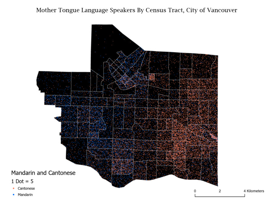
The map you create will look something like this image below.
GIS Resources at UBC
- General Informational website for all things UBC GIS: gis.ubc.ca
- UBC Library’s guide for finding and working with GIS resources: guides.library.ubc.ca/gis
- UBC’s GIS email list (participate or lurk!): UBC GIS ListServ
- UBC’s GIS Slack (create your own channel or lurk!): ubcgis.slack.com
- Sign up for a GIS consultation at the Research Commons
- UBC Library GIS Help email: library.gis AT ubc.ca
- GIS software purchase from the UBC Webstore
Setup
This workshop requires the installation of Esri ArcGIS Pro.
Remote Access
You can access ArcGIS Pro via remote workstation on UBC Library’s lab computers on a first-come-first-serve basis. Log in with your CWL to access remote labs here: remote labs. Log into computers in:
- Digital Scholarship Lab (RM 497) newest machines
- Koerner Library Computer Lab (RM 217)
- Data/GIS Lab (RM 218 A)
Purchase Software as a Student
The software is also available to UBC Students from the UBC Webstore. Students are eligible to download the ArcGIS suite for a fixed amount per year.
Operating ArcGIS Pro on a Mac
ArcGIS Pro works best on a Windows operating system. For more information about running it on a Mac, see Run ArcGIS Pro on a Mac.
Sign Up for a Free Trial
If you do not want to purchase a license, you can sign up for a free 21-day trial.
Sign Into ArcGIS Online
Depending on the type of license you have, you may need to sign into ArcGIS Pro. If you purchased the UBC ArcGIS student license, you can sign into the same account you use for ArcGIS Online. You can also create a free public ArcGIS Online account to use if you have a temporary ArcGIS Desktop license. We will be accessing data on ArcGIS Online via ArcGIS Pro, so signing in is recommended.
Download Workshop Data
To get started with this workshop, you’ll need to first download a geodatabase of mother tongue language data for Vancouver, as well as a project folder, the contents of which are described below.
Included in your download is a project folder containing the following files:
- Intro.gdb: the geodatabase with data for your map
- Intro.aprx: the project file with all the maps
- Intro.tbx: a toolbox with analytical tools for your project
- Index: folder with background organizing information
1 Save this file (.zip) to your Desktop.
2 Right-click on the .zip file you just downloaded and select Extract All…
3 Accept all defaults to extract the file.