Spatial Data
GIS often represents data in a 2 dimensional plane or using some coordinate reference system
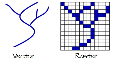
Vector
Vector data is simpler, it encompasses points, lines, and polygons of any shape.
Raster
Raster data uses pixels (many of them!) to represent real-world images, e.g., a satellite picture.
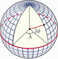
Coordinate Reference System
A spatial reference system or coordinate reference system is a coordinate-based local, regional or global system used to locate geographical entities. For example, Latitude and Longitude can represent spatial data for virtually any point on earth!
1 Loading Spatial Data in R
For this workshop, we will focus on vector data. Similar operations exist for raster, we have provided multiple links under resources.
R Code
# load vector
vancouver_boundaries <- st_read("local-area-boundary.shp")
Inspecting a file’s meta-data
2 Coordinate Reference System
We obtain the crs of out data using the st_crs function. This function is not heavily used in this workshop albeit it is extremely important as you might have to work with data from different crs and you may need to convert from one crs to another.
R Code
st_crs(vancouver_boundaries)$proj4string
3 Types of Geometry
There are different types of geometry, e.g. lines, polygons, dots, etc. We can inspect what our data has with st_geometry_type
R Code
st_geometry_type(vancouver_boundaries)
unique(st_geometry_type(vancouver_boundaries))
4 Bounding Boxes
Finally, our map has certain boundaries, we inspect boundaries with st_bbox. Again, for this workshop everything is within the same boundaries, but merging maps might be more challenging.
R Code
st_bbox(vancouver_boundaries)
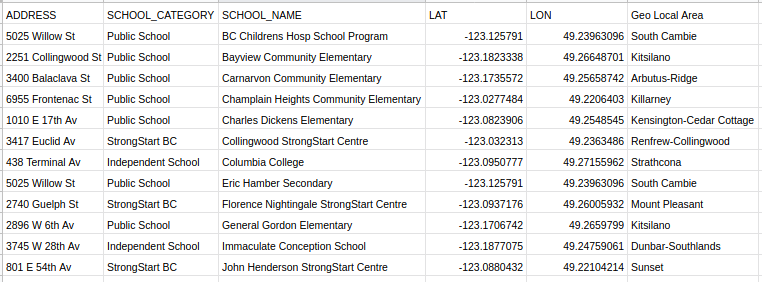
Converting Tabular Data to Spatial Data
In certain cases, you may not have access to vector or raster files. Nonetheless, you have recorded some geo spatial feature as part of your data collection methodology.
R Code
# Load tabular data
tbl <- read.csv("schools.csv", header=TRUE, sep=";")
5 Provided that you have some geo spatial feature, e.g., postal codes, you can convert your data with the st_as_sf function. Note that it is extremely important to provide a crs.
R Code
crs_vancouver <- st_crs(vancouver_boundaries)
schools <- st_as_sf(tbl, coords = c("LON", "LAT"), crs = crs_vancouver)
Data Needed for this Workshop
Let’s load the data for the workshop
R Code
transit_routes <- st_read("Shapes_Trips_Routes.shp")
schools <- st_read("schools.shp")
libraries <- st_read("libraries.shp")
community_centres <- st_read("community-centres.shp")
disability_parkings <- st_read("disability-parking.shp")
Recap
1 st_read reads a shape file
2 st_crs views coordinates of shape data
3 st_geometry_type views geometry of the data, e.g., polygons, lines, dots, etc.
4 st_bbox views boundaries of data
5 st_as_sf converts from tabular to spatial data